Kameelburg REE Niobium Project
KAMEELBURG PROJECT – GEOLOGY
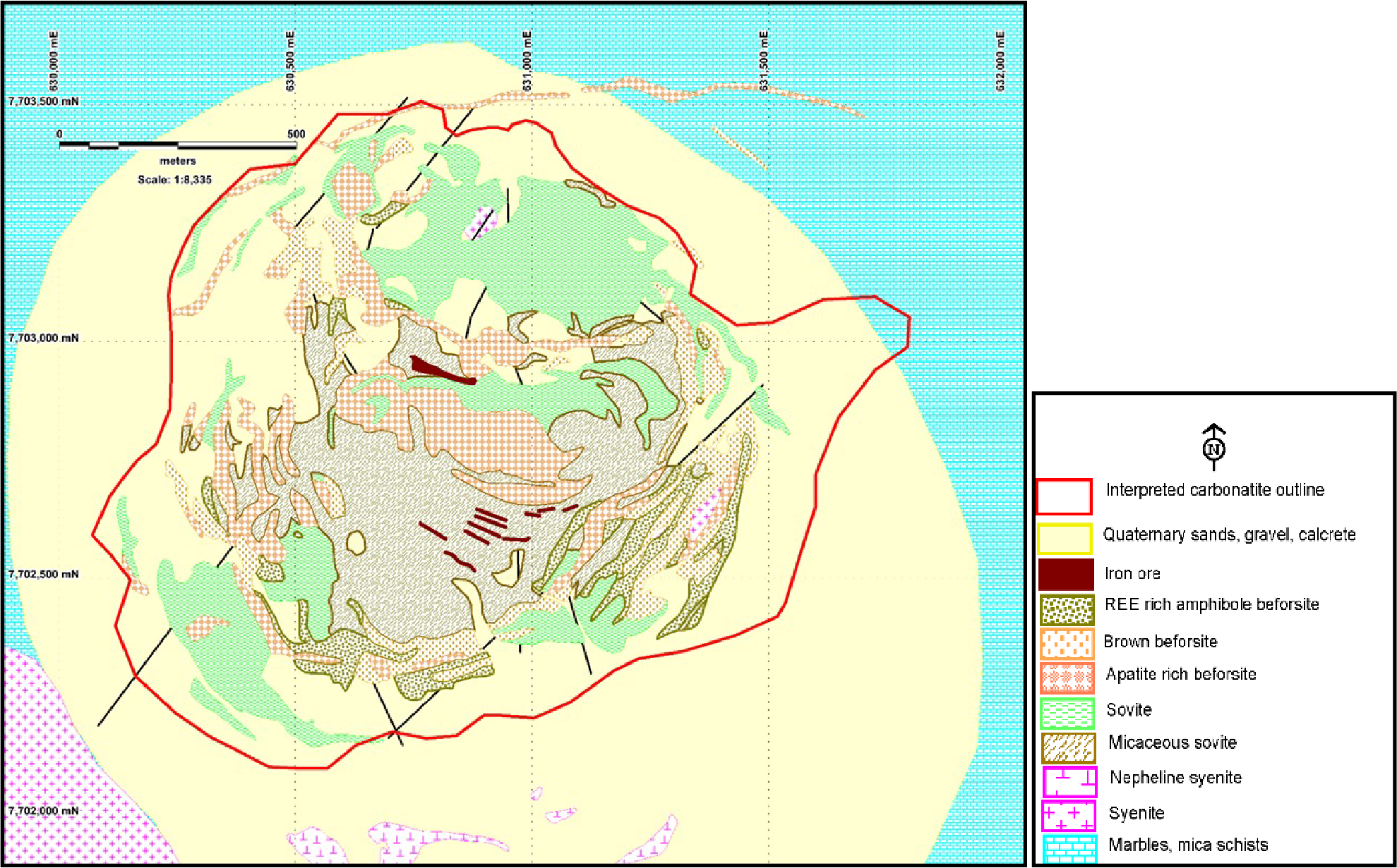
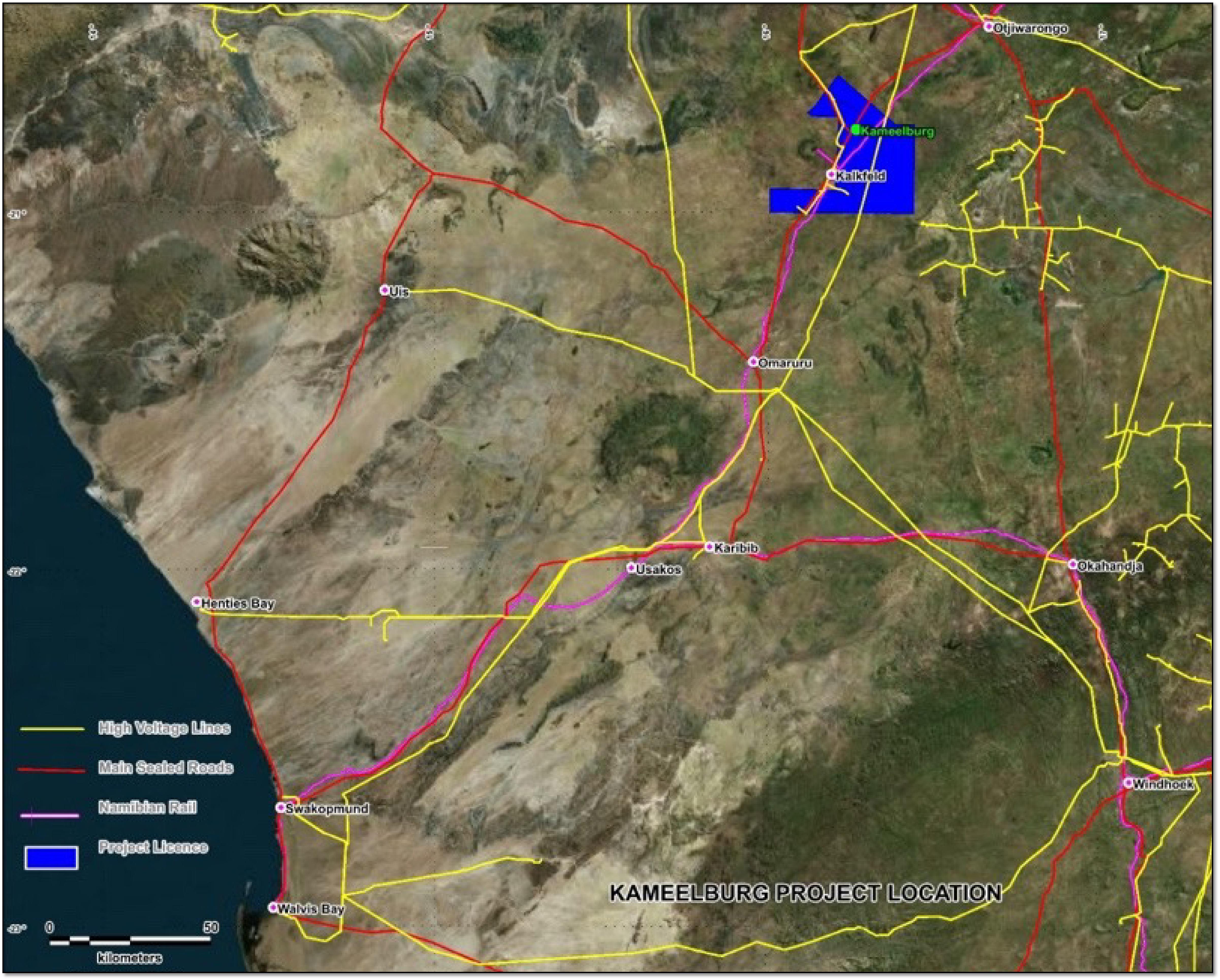
The Kameelburg Project is located in the northern Central Damara Orogenic Belt in Namibia and covers the Cretaceous Kameelburg Carbonatite plug and associated radial dykes intruding precursor syenites in the older host Neoproterozoic marbles and schists. The plug is approximately 1.4km in diameter and rises up to 276m above the surrounding peneplain. The intrusion consists of an initial pre-curser phase of nepheline syenite/syenite followed by two sovite and three beforsite phases with remanent rafts of volcanic breccia and syenite, the vestiges of earlier intrusive phases. (Verwoerd,2008)
The country rock consists of marbles, quartzite’s, mica schists of the Damara Supergroup. Rare earth metals are known to occur in all three phases with higher concentrations in the more magnesium and iron rich beforesites. Initial mineral investigations were conducted in the late 1960’s early 1970’s by AMCOR and the project lay dormant until 2012-2015 when it was investigated by a private company for REE and phosphates but low commodity prices during this period ended investigations.

Figure 4: Geological Map of the Kameelburg Carbonatite derived from published data (after Prins, 1981). Datum WGS84_33S.
KAMEELBURG PROJECT – HISTORICAL EXPLORATION
1) AMCOR (1967 – 1970)
AMCOR conducted exploration over Kameelburg from 1967 to 1970 using the National Institute of Metallurgy (NIM) to commission investigations into the surface rock sampling (12 rock chips), 11 drill holes and 2 bulk samples into the carbonatite, producing 3 technical reports which were obtained from the Council of Geosciences (RSA). The limited work found:
- The intrusion is a vertically concentrically layered body with an ENE elongation (1,280 x 1,070m) with a phosphatic and ankerite rich elongated core (120x600m) surrounded by micaceous carbonatite (sovite).
- The core has an alteration halo and is surrounded by “shells” of carbonatite (magnetite and pyrrhotite) with the pipe fingers containing discontinuous zones of ring dykes and plugs rich in phosphate and/or REE. Nepheline Syenite flanks the southern margin with marbles to the north.
- The main facies identified were sovite and beforsite with transitional rocks where these and the beforsite were considered the enriched rocks in Th, REE, Sr, Nb and P with variable zoning both laterally and vertically.
- 11 holes were drilled at shallow dips (300) across various segments of the intrusion including the phosphatic core and the surrounding flanks. Petrology from some 44 rock samples identified ancylite (La, Ce), Cerianite (Ce), Strontianite (Sr), Fluoroapatite (Ce, P), Pyrochlore (REE, Nb), Columbite (Nb) as well as calcite, Parankerite, siderite, apatite, magnetite, rutile, leucoxene, quartz, rutile, chalcopyrite, pyrite and hydrated iron oxides.
- A bulk sample of surface rock from the phosphatic core was upgraded by magnetic separation to produce a concentrate of 31.8% P2O5 and 1.6% TREO. A second bulk sample at the eastern edge of the pipe from an iron-rich ring dyke (180x762m) produced grades of 2.6% TREO.
2) KINLOCH RESOURCES (2012 – 2013)
Kinloch Resources Pty Ltd undertook two phases of sampling in 2012 – 2013. This involved a due diligence rock chip sampling program and a grid-based rock and soil sampling program.
- The due diligence program collected 29 rock and 34 soil samples on a cross hair traverse at 100m intervals. Laboratory analytical data found up to 1.81% TREE in the rocks and up to 1.75% TREE in the soils. These sampling results showed that parts of Carbonatite, in particular the beforsite and possibly some of the micaceous sovite, are well endowed.
- The detailed 100m centered grid of rock and regolith sampling completed over the Kameelburg Carbonatite and surrounding country rock contacts involved the collection of 678 rock and regolith samples from 339 sites. The results from the soil sampling recovered TREO (including Y2O3) values up to 2.66% and averaging 1.3% over the carbonatite and P2O5 values up to 9.7%. The rock chip samples recovered values up to 5.56% TREOs, averaging 1.0% over the carbonatite and up to 17.25% P2O5. Anomalous values of Strontianite, up to 13.2% and Niobium Pentoxide, up to 4.75% were also recorded although somewhat more sporadic in occurrence.
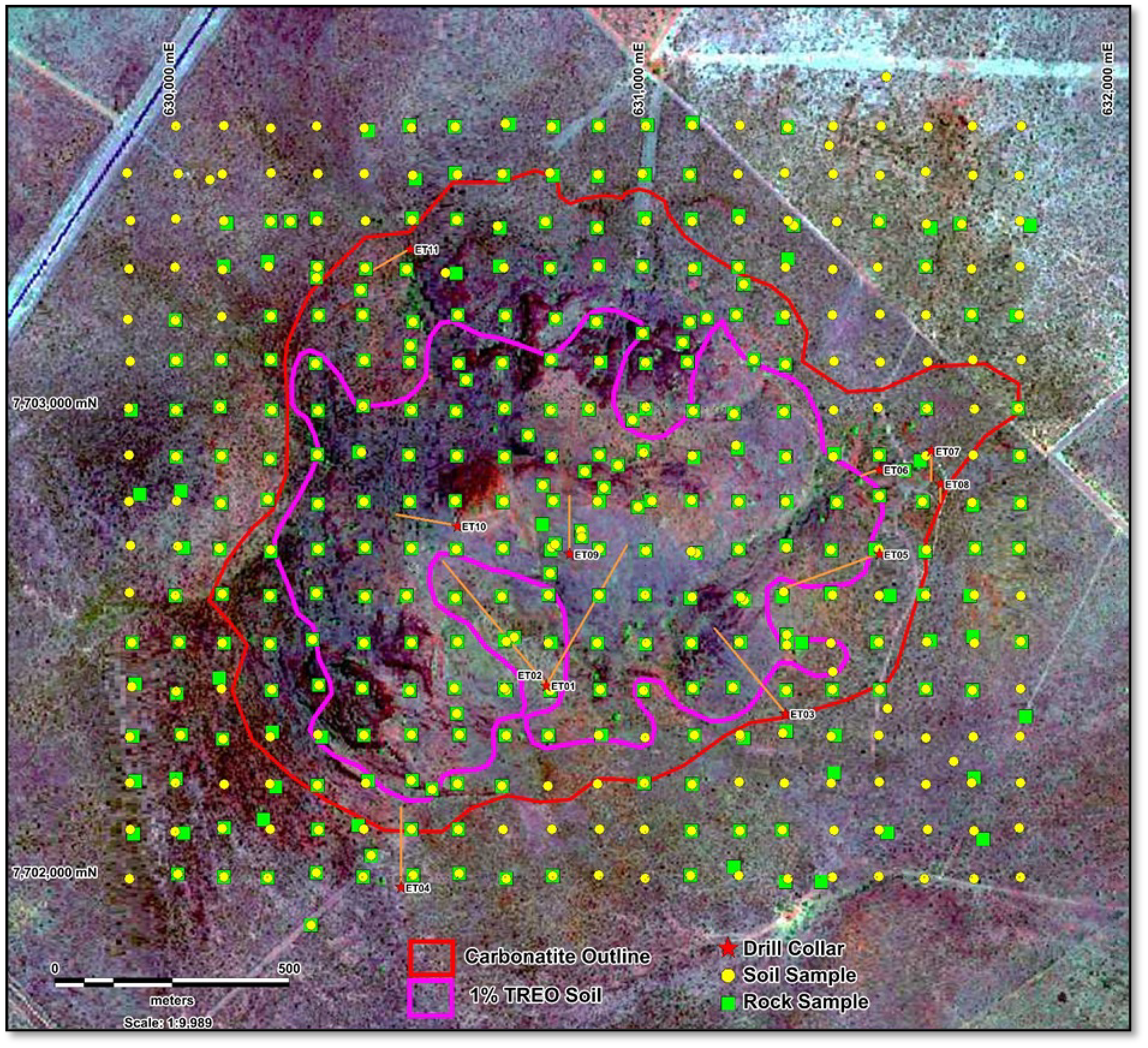
- The grid samples were contoured, which found the average of the soil samples in the area to be >1% TREO (0.838km2) contour was 1.44%. Rock chip results recovered values up to up to 5.56% TREOs with the average from within the >1% TREO (0.838km2) contour being 1.27% TREO.

Figure 5: 1% TREO contour used for the area calculations and the sample points. Squares are rock samples and yellow circles represent soil samples on the 100m grid.
Kameelburg Sampling – TREO Results
| Soil | Rock Chip | Area,km2 | |
| TOTAL GRID | 3.04 | ||
| Number | 410 | 312 | |
| Highest Value | 2.66 | 5.56 | |
| Average % | 0.78 | 0.76 | |
| CARBONATITE | 1.606 | ||
| Number | 211 | 152 | |
| Highest Value | 2.66 | 5.56 | |
| Average % | 1.09 | 1 | |
| >1% CONTOUR | 0.838 | ||
| Number | 107 | 79 | |
| Highest Value | 2.66 | 5.56 | |
| Average % | 1.44 | 1.27 |

The Forward work programme aim to develop a metallurgical flow sheet for the recovery of REE and Niobium, conduct targeting geochemical sampling and geological mapping aided by high resolution photography towards developing a mineralisation model and provide data for drilling. The targeted drilling will enable the establishment of a resource model aided by the digital elevation model (DEM) from the orthophotos.
References
Verwoerd, (2008): Ondurakorume Carbonatite Complex by V.J. Verwoerd in Geological Survey of Namibia Publication: The Geology of Namibia, Vol3: Palaeozoic to Cenozoic by R.McG.Miller. Section 18.4.
Prins (1981): Figure 18.9 page 18-23, Section 18.4 Ondurakorume Carbonatite Complex by V.J. Verwoerd. Geological Survey of Namibia Publication: The Geology of Namibia, Vol3: Palaeozoic to Cenozoic by R.McG.Miller


